PD1010 – Scenic Aerial View of Panvel Landscape with Old Mumbai-Pune Highway (NH 48)
- ₹11,800.00
Description
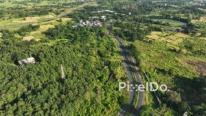
A beautiful high-angle aerial drone shot over the lush green landscape of the Panvel area. The video captures the winding path of the Old Mumbai-Pune Highway (NH 48) and a railway line running through the valley. Surrounded by mountains and fields, the distant Hiranandani township high-rises are visible, showing the expansion of the city. This clip highlights the stunning contrast between nature and rapid urban development under a partly cloudy sky.


PD0973 - Drone Pans Over Coastal Highway Cutting Through Scenic Wetland
PD0221 - Residential Suburb of Chembur in Mumbai
PD0770 - Aerial Drone Shot of Mumbai's Skyline During a Golden Sunset
PD0870 - Aerial Orbit of Chennai's TIDEL Park and IT Corridor
PD1107 - Aerial Drone Pan of Train, Forest, and Cityscape at Sunset
PD1163 - Aerial Drone Flight Over Vashi Toll Naka and Vashi Bridge
PD1122 - Aerial Drone View of Mahalaxmi Racecourse and Worli Skyline